

coming soon
Arbor Day is a nationally celebrated observance that encourages tree planting and tree care. The first Arbor Day was celebrated in the state of Nebraska in 1872, in response to a state proclamation urging settlers and homesteaders in that prairie state to plant trees that would provide shade, shelter, fruit, fuel, and beauty for residents of the largely treeless plains. On that first Arbor Day, more than one million trees were planted in Nebraska's communities and on its farms.
The Arbor Day idea was promoted by J. Sterling Morton, editor of the Nebraska City News who later helped the idea spread to neighboring states and eventually to all of the United States and many other nations.
Today, Arbor Day celebrations are held in communities all over America, with the date determined by the best tree planting times in each area. Celebrations are held as early as January and February in some southern states, and as late as May in more northern locations. National Arbor Day is observed on the last Friday in April.
The idea for Arbor Day originally came from Nebraska. A visit to Nebraska today wouldn't disclose that the state was once a treeless plain. Yet is was the lack of trees there that led to the founding of Arbor Day in the 1800's.
Among pioneers moving into the Nebraska Territory in 1854 was J. Sterling Morton from Detroit. He and his wife were lovers of nature, and the home they established in Nebraska was quickly planted with trees, shrubs and flowers.
Morton was a journalist and soon became editor of Nebraska's first newspaper. Given that forum, he spread agricultural information and his enthusiasm for trees to an equally enthusiastic audience. His fellow pioneers missed their trees. But, more importantly, trees were needed as windbreaks to keep soil in place, for fuel and building materials, and for shade from the hot sun.
Morton not only advocated tree planting by individuals in his articles and editorials, but he also encouraged civic organizations and groups to join in. His prominence in the area increased, and he became secretary of the Nebraska Territory, which provided another opportunity to stress the value of trees.
By Kyle Poage, Meteorologist for Topeka NWS
Although January and February had their share of cold temperatures and wintry precipitation events, a very warm and dry December pushed the winter season of 2021-2022 into the warm and dry categories. Temperatures for the season averaged to be around two degrees above normal across north-central, northeast, and east-central Kansas with precipitation around one-third of normal. In particular, for Topeka, where weather records date back to 1887, the winter was the ninth-driest with a total of 1.43 inches of precipitation, which is 2.40 inches below normal. It was also the twelfth-warmest winter with an average temperature of 35.4 degrees, which is 2.6 degrees above normal. The average low temperature for the season was close to normal, but the average high temperature was 5.5 degrees above normal, placing it as the second-warmest average high temperature on record. Only the winter of 2011-2012 had a warmer average high temperature. The total snowfall for the winter season was 14.8 inches, which is 0.9 inches above normal. For Concordia, where weather records date back to 1885, it was the third-driest winter with only 0.49 inches of precipitation falling, which is 2.10 inches below normal. The average temperature tied for the sixteenth-warmest winter season on record, 3.0 degrees above the normal of 34.0 degrees. As was the case for Topeka, the average high temperature was what made the winter warm. The average high temperature tied for the highest average on record at 47.1 degrees, 6.0 degrees above normal, tying with the 1991-1992 season.
Again for Topeka, December 2021 was the secondwarmest and eighth-driest December on record. The high temperature on December 15th was 76 degrees and the high temperature on December 24th was 74 degrees. These readings were the second- and thirdhighest temperatures on record for any December, respectively. The first measurable snow of the season came January 1st. This was the eighth-latest first snowfall of the winter season on record. This area’s first snowfall of the season was heaviest in northern areas with 4.0 inches measured at Belleville, Concordia, and Holton with around an inch falling south of the Kansas Turnpike. Wind chill values were rather cold January 1st and 2nd with readings of -10 to -20 degrees being common. Another round of cold followed on January 6th with wind chills of -8 to -15 that morning. Another moderate snowfall occurred from late January 14th to late January 15th with around three inches accumulating in northeast and east-central Kansas. A somewhat longer-lived snow fell from the afternoon of February 1st to around sunrise of February 3rd with the heavier amounts falling in east-central Kansas, including five inches at Osage City, 4.6 inches at Topeka, and four inches at Gridley. Wind chills as the storm ended fell to -8 to -13 degrees across the area. A shorter duration but heavier snow fell from around midnight to the afternoon of February 17th, with again the heaviest snow falling in east-central Kansas, with 9.1 inches measured at Eudora, eight inches at Osage City, and six inches at Garnett. This event began as a wintry mix of precipitation with freezing rain and some thunderstorms. February 23rd saw the final cold snap of the season with wind chills of -8 to -20 that morning.
Source: https://www.weather.gov/media/top/newsletter/Spring%202022%20Topeka%20Tiller.pdf
By Sarah Kessinger.
From the April 21, 2022 edition of The Marysville Advocate (republished with permission).
A new children's zip line and a spider web climbing station are among new features recently added to Summerfield's City Park. The effort, part of the town's CPR — Community Park Restoration — is gradually updating the park's infrastructure while adding a brand new playground structure and other attractions. "We've actually put in new playground equipment and a really neat zip line and spider web that kids can climb on," said Becky Wiebe, member of a volunteer committee organizing the park renovation. The updates and new park lighting are phase two of a three-phase plan. Earlier improvements included new lines on the tennis and pickleball court, adjustable basketball goals, and updated sand volleyball pit.

A zipline is among the highlights of the park’s new features and updated facilities. All of the play equipment has been improved or replaced.
Phase three includes a new shelter house and sidewalks. The current shelter house is being auctioned off on the Summerfield City Park Facebook page. In the meantime, the new equipment is up and ready for kids. There is also a rehabilitated geodome, monkey bars, swings and a Maypole. A generational swing is available with an adult seat and a child seat. There are other specialized swings. Once the park is completed it should meet Americans With Disabilities Act guidelines on sidewalks as well. "We want you to come and play. It's open for everyone to enjoy now," Wiebe said. Volunteers and their equipment have done all the installations and other park improvements. Young adult AmeriCorps volunteers helped with part of the earlier work.
"Our farmer guys are now busy planting, so when they have time again, we'll work on phase three," Wiebe said. Anyone who would like to donate to the project can still do so by sending checks to Summerfield CPR, P. O. Box 100, Summerfield, Kansas 66541.
Rubber mulch has been spread on the main playground, and wood mulch is the base for the zip line area. Volunteer Gay Frazee said the committee received two matching grants for the park project. One came from a federal Land & Water Conservation Fund and the second from Kansas Department of Health and Environment's Waste Tire Grant fund. The project's fundraising paid for grant match requirements.
Volunteers work on the shelter house for the Summerfield Park.
Frazee said the waste tire grant involved 1,241 volunteer hours for phase two, plus 439.5 hours of donated equipment and 107,755 pounds of rubber mulch crumbs as playground covering.

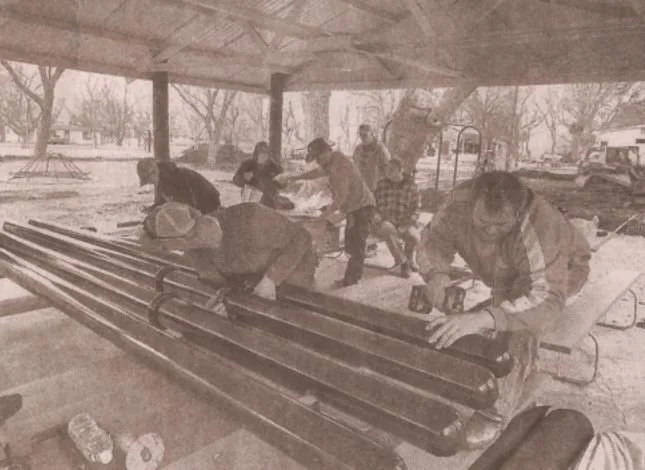
A volunteer crew spent weekends in March assembling a new playground at Summerfield’s park. The equipment is part of a restoration of the entire park.
"Every recycled tire produces 15 to 20 pounds of mulch," Frazee noted, "so we used well over 6,000 recycled tires in our playground!"
Local children, Frazee said, are enjoying the updated park.
"They think it's the best thing ever."
Coming soon.
Coming Soon
A powerful spring storm delivered significant, late season snow from the Cascades and Sierra Nevada to the northern Plains, stressing livestock in the middle of the calving and lambing season. High winds and blizzard conditions accompanied the snow, especially across the northern Plains, causing substantial travel disruptions. Farther south, drought conditions worsened across the central and southern Plains and the Southwest, amid windy, dry conditions. At times, winds raised dust and contributed to the rapid spread of several wildfires, including the 6,159-acre McBride Fire, which was ignited on April 12 in Ruidoso, NM, and destroyed more than 200 homes. Meanwhile, heavy showers and locally severe thunderstorms swept across the Mississippi Delta and environs, producing widespread rainfall totals of 2 to 4 inches or more and causing localized wind and hail damage. Significant rain fell in other areas, including parts of the Midwest and Northeast, although mostly dry weather prevailed along the middle and southern Atlantic Coast. Warm weather prevailed for much of the week across the South, East, and lower Midwest, boosting temperatures more than 10°F above normal across portions of the southern Plains and scattered locations in the middle and northern Atlantic States. In contrast, a harsh cold snap engulfed the northern Plains and the Northwest, holding weekly temperatures at least 10 to 20°F below normal from the Cascades to the Dakotas. In fact, chilly weather broadly covered much of the remainder of the western U.S., as well as the upper Midwest.
As the week began, cool weather lingered along the Atlantic Coast. In Florida, Vero Beach (43°F) noted a daily-record low for April 10. Meanwhile, increasingly cold weather spread across the northern Plains and much of the West. By April 12, daily-record lows in California dipped to 7°F in South Lake Tahoe, 31°F in Redding, and 33°F in Sacramento. Sub-zero temperatures settled across the northern Rockies, where Lake Yellowstone, WY, registered a low of -18°F on April 13. From April 13-16, Billings, MT, logged lows of 9, 4, 10, and 15°F, breaking daily records each day by at least 5°F. Billings also recorded its latest-ever reading below 5°F (previously, 0°F on April 5, 1936). Elsewhere in Montana, the temperature in Cut Bank remained continuously below 32°F from April 11-16. By the 16th, single-digit lows were common across snow-covered areas in North Dakota, where temperatures fell to 8°F in Minot and Grand Forks. With a low of 0°F on the 16th, Bismarck, ND, experienced its latest-ever reading of 0°F or below—and its coldest April weather since 1996, when it was -1°F on April 5. Great Falls, MT, closed the week with consecutive daily-record lows (7 and 8°F, respectively) on April 15-16. Mid-week temperatures briefly plunged across the central and southern Plains, threatening the already drought-stressed winter wheat crop. Denver, CO, registered 10°F on April 13, a record for the date, followed the next day by dailyrecord lows of 4°F in Sidney, NE; 9°F in Colby, KS; and 22°F in Dalhart, TX. Unusually cold conditions also gripped the Northwest, where the 15th featured the lowest-ever April temperatures in Washington locations such as Ephrata (19°F; previously 21°F on April 2, 1999, and April 19, 2008) and Wenatchee (23°F; previously, 25°F on April 21, 2008). In stark contrast, heat surged northward in advance of a strong cold front. In Texas, a wave of record highs on April 12 included maxima of 103°F in Laredo and Del Rio. On the same date, daily-record highs climbed above the 90-degree mark in Grand Island, NE (92°F), and Concordia, KS (92°F). McAllen, TX, notched a daily-record high of 107°F on April 13. By the 14th, warmth reached the Atlantic Coast States, where Newark, NJ, attained 88°F—a record for the date. Meanwhile, heat quickly returned across the southern High Plains, where Lubbock, TX, posted a record-setting high (92°F) for April 15.
Early in the week, rare April snow fell at lower Northwestern elevations. The airport in Portland, OR, which had never experienced a measurable April snowfall, received 1.9 inches on April 11-12. The airport’s previous latest snow had fallen on March 25, 1965, when 0.3 inch fell. Downtown Portland, hit with 2.0 inches of wet snow on April 11, also set a record for its latest accumulation (previously, 0.1 inch on April 10, 1903). Meanwhile, high winds raked the Plains and Southwest. On April 10, a gust to 78 mph was clocked in Raton, NM. Two days later Broken Bow, NE, recorded a gust to 62 mph. Meanwhile in North Dakota, April 12-14 snowfall included 12.6 inches in Grand Forks (National Weather Service office) and 18.3 inches in Bismarck. Stormtotal snowfall topped 2 feet in several North Dakota communities, including Velva (28.0 inches), Lansford (27.5 inches), Dunn Center (26.0 inches), and Underwood (24.3 inches). During the storm, a wind gust to 54 mph was clocked in Bismarck; elsewhere in North Dakota, gusts reached 60 mph in Dickinson and 63 mph in Minot and Hettinger. Measurable snow fell in Great Falls, MT, each day from April 11-17, totaling 12.2 inches. Farther west, the first-ever measurable April snow fell at the agricultural experiment station in Wenatchee, WA. Incredibly, the Wenatchee Experiment Station received 10.4 inches of snow on April 14, boosting its month-to-date total to 13.1 inches. A neighboring station, the Wenatchee Water Plant, received a storm total of 5.4 inches, breaking its April 1935 record of 0.5 inch. Elsewhere, a severe weather outbreak affected various parts of the Plains, Midwest, and South from April 11-14. On April 11, hail up to 4.5 inches in diameter fell in Logan County, AR, while a tornado was spotted by the observer at Little Rock Air Force Base. On April 12, an EF-3 tornado injured at least 23 people in Bell County, TX, near Salado. The same day, at least two tornadoes were documented in Minnesota, where an EF-2 twister in Mower County struck the community of Taopi. A thunderstorm wind gust to 75 mph occurred on April 13 at Hawkins Field in Jackson, MS. The midSouth remained the focus of heavy showers for several days; in Arkansas, daily-record totals included 2.81 inches (on April 13) in Stuttgart and 1.72 inches (on April 16) in Hot Springs.
Mild, mostly dry weather in western Alaska contrasted with dry but increasingly cold conditions in eastern and southeastern parts of the state. By April 14, daily-record lows were set in Ketchikan (26°F) and Sitka (29°F). Ketchikan logged another daily-record low (25°F on April 16). Juneau collected consecutive daily-record lows (20 and 21°F, respectively) on April 14-15. Farther north, however, Fairbanks achieved a high of 50°F on April 14. Meanwhile, windward slopes in Hawaii experienced a significant increase in shower activity, especially late in the week, but leeward locations remained mostly dry. On the Big Island, Hilo netted 4.71 inches of rain (not a record for the date) on April 16, boosting its month-to-date sum to 10.68 inches (196 percent of normal). However, April 1-16 rainfall totaled less than one-tenth of an inch in Honolulu, Oahu (0.02 inch, or 4 percent of normal), and Kahului, Maui (0.06 inch, or 8 percent). Kahului also tallied a trio of daily-record highs (88, 88, and 89°F) from April 10-12.
Source: https://www.usda.gov/sites/default/files/documents/wwcb.pdf


Youth Archery March 25 – May 31, 2022
Archery March 25 – May 31, 2022
Youth Shotgun April 9 – May 31, 2022
Shotgun April 16 – May 31, 2022
Resident: $30 | Nonresident: $128 | Youth: $8
All permits must have a $25 habitat stamp.
Permits may be bought at Game and Parks permitting offices including:
State Bank Of Table Rock
402 Houston
Table Rock, NE
or online at https://ngpc-home.ne.gov/ps/faces/index.xhtml
or by mail:
Nebraska Game and Park Commission
2200 N. 33rd St.
P.O. Box 30370
Lincoln, NE 68503-0370
If you have a smart phone go to http://outdoornebraska.gov/mobilepermits/


April 1-12, 2022 is open to youth and disabled hunters. April 4, 2022 through April 12, 2022 is bow hunting season. The regular season begins on April 13, 2022 and ends on May 31, 2022. Please check dates with official regulations.
Spring turkey permits and game tags may be purchased online, at any vendor location or by phone from March 1 - May 31, 2022. In addition to your turkey permit and tag, you must have a Kansas hunting license, unless exempt by Kansas Law.
Kansas youth (15 and under) may purchase a youth spring turkey permit valid statewide for $7.50. Nonresident youth (15 and under) may purchase a youth spring turkey permit valid statewide for $12.50.
In Marshall County permits can be purchased at several locations including:
WAL-MART #341
1174 Pony Express Hwy
Marysville, KS 66508
(785) 562-2390
Source: https://ksoutdoors.com/Hunting/Applications-and-Fees/Turkey
Much of the eastern half of the nation received substantial precipitation, with weekly totals ranging from 2 to 4 inches or more in parts of the South and Northeast. Severe thunderstorms accompanied the Southern showers; several dozen tornadoes were spotted on April 4-6 from northeastern Texas to the southern Atlantic Coast. Meanwhile, rain and snow showers were common across the Midwest, although significant snow accumulations were generally confined to the upper Great Lakes region. The cool, showery Midwestern weather limited spring fieldwork, especially in wetter areas across the eastern Corn Belt. Elsewhere, mostly dry weather prevailed from the West Coast to the High Plains, except in the Pacific Northwest. In California and environs, a second heat wave in 3 weeks led to further reductions in high-elevation snowpack and resulted in unusually heavy irrigation demands so early in the year. California’s early-season heat boosted weekly temperatures at least 10°F above normal in a few locations. Near or above normal temperatures were also prevalent across the Plains, Deep South, and Atlantic Coast States. In contrast, readings averaged more than 5°F below normal in some Midwestern locations. Near or below normal temperatures were common across the Northwest, which experienced cooler weather as the week progressed.
Early in the week, Eastern warmth was mostly limited to southern Florida, where Fort Myers posted a daily-record high of 90°F on April 4. The following day, hot weather surged into the south-central U.S. in advance of an approaching cold front. In Texas, daily-record highs for April 5 included 100°F in Del Rio; 97°F in Waco; 96°F in Childress; and 95°F in San Antonio, Wichita Falls, and Dallas-Fort Worth. Elsewhere on the 5th, Lawton, OK, posted a daily record high of 92°F. A monthly record was established on April 6 in McAllen, TX, where the high of 109°F clipped the former mark of 107°F, set on April 26, 1984, and April 27, 2014. With a high of 104°F on the 6th, Brownsville, TX, tied a monthly record originally set on April 26, 2017. Meanwhile, hot weather also persisted in parts of Florida, where record-setting highs for April 6 surged to 93°F in Orlando and 92°F in Vero Beach. Farther west, cooler air arrived in the Northwest, while heat developed across much of California. On April 6, daily-record lows in Oregon dipped to 11°F in Burns and 16°F in Redmond. Olympia, WA (25°F), also posted a recordsetting low for April 6. However, consecutive daily-record highs were established on April 7-8 in California locations such as Long Beach (100 and 101°F, respectively); Los Angeles International Airport (95 and 97°F); and Fresno (94 and 96°F). The only previous April dates Long Beach had experienced readings of 100°F or greater were April 4-6, 1989; April 26, 2004; and April 20, 2009. On April 8, triple-digit, daily-record highs were also observed in southern California locations such as Anaheim (106°F), Santa Ana (103°F), and Escondido (102°F). Record-setting warmth briefly spread to the northern High Plains; in Montana, highs for the 8th soared to 80°F in Helena and 78°F in Lewistown. Conversely, sharply cooler air punching into the South resulted in daily-record lows for April 9 in Arkansas locations such as Russellville (28°F) and Little Rock Air Force Base (28°F).
With a pair of spring storms crossing the North, high winds were observed in several areas. In Montana, April 4 wind gusts were clocked to 69 mph in Cut Bank and 63 mph at Dillon Airport. Ongoing high winds in Montana on April 5 resulted in gusts to 66 mph in Lewistown and 62 mph in Helena. Later, numerous damaging wind gusts related to Southern thunderstorm activity were reported from April 4-7. At Craig Airport in Jacksonville, FL, a thunderstorm-produced gust to 57 mph was reported on April 7. Elsewhere on the 7th in Florida, a gust to 82 mph was recorded in Fort Pierce. Two days earlier, on April 5, a thunderstorm wind gust to 77 mph had been noted in Crestview, FL. April 5 also represented a peak day for tornadic activity, with as many as six dozen twisters spotted—based on preliminary reports—from Mississippi to South Carolina. Southern daily-record rainfall totals included 4.48 inches (on April 5) in Hattiesburg, MS; 4.16 inches (on April 6) in Macon, GA; and 2.90 inches (on April 7) in Jacksonville, FL. A wave of Northeastern daily rainfall records occurred on April 7, when calendar-day totals reached 2.14 inches in Scranton, PA, and 2.03 inches in Albany, NY. Heavy rain lingered in New England through April 8; daily-record totals on that date included 2.11 inches in Portland, ME, and 1.03 inches in Concord, NH. Meanwhile, snow showers developed across the Midwest and pushed into parts of the South and East; daily-record totals reached 0.1 inch (on April 7) in Sisseton, SD, and a trace (on April 8) in Harrison, AR. Duluth, MN, netted 8.0 inches of snow from April 5-7. By April 9, strong winds—not associated with thunderstorms—returned across the Southeast. With a gust to 58 mph on the 9th, Gainesville, FL, set a monthly record, previously attained with a gust to 56 mph on April 30, 2010. On the central and southern Plains, windy weather raised dust and fanned several early April wildfires; in south-central Nebraska, the Road 739 Fire burned some 35,000 acres of vegetation and destroyed nearly five dozen structures, while in western Oklahoma, the Beaver River Fire torched nearly 25,000 acres and a dozen structures.
Wintry temperatures (locally more than 10°F below normal) returned across much of mainland Alaska. Kotzebue reported sub-zero minima each day from April 2-9, including a low of -25°F (not a record for the date) on the 8th. Meanwhile, mild, showery weather covered southeastern Alaska. April 1-9 precipitation totaled 3.60 inches (149 percent of normal) in Yakutat and 3.31 inches (107 percent) in Ketchikan. Farther south, Hawaii’s regime featuring warm, mostly dry weather persisted, especially in leeward locations. On Maui, Kahului notched a daily record-tying high of 87°F on April 5. At the state’s major airport observation sites, month-to-date rainfall through April 9 ranged from a trace in Kahului to 3.50 inches (108 percent of normal) in Hilo, on the Big Island. The bulk of Hilo’s rain fell during the mid- to late-week period, with 2.23 inches noted from April 6-9.
Source: https://www.usda.gov/sites/default/files/documents/wwcb.pdf
In the Summerfield area, morel season begins in early April and extends into mid May. For the beginning mushroom hunter, morels are among the easiest to find and identify of the hundreds of wild mushrooms growing in our area.
Like all wild mushrooms, morels require specific conditions of temperature and moisture to grow. Some springs are good for morels, others poor. Morels grow best in warm, wet, and humid conditions. They favor timber over pastures and can be particularly numerous in recently burned areas.
Many mushrooms are poisonous so never eat any mushroom if you are not 100% sure it is safe to eat.
Probably the easiest way to prepare morels is to coat them in flour and pan fry them in bacon grease.
Please get permission to hunt mushrooms on private property. Burchard Lake and Pawnee Prairie are both good locations for mushroom hunting. Since mushroom season coincides with tick season, be sure to prepare accordingly.

Morel Mushroom
Another week of active weather included a severe weather outbreak, which swept eastward from the central and southern Plains to the middle and southern Atlantic States from March 29-31. During the outbreak’s peak, on March 30, dozens of tornadoes were spotted across the South, extending as far north as southern Illinois. Before dawn on March 31, two tornado-related fatalities were reported in northern Florida near Alford. Heavy rain accompanied the severe weather, with 1- to 3-inch totals common from the mid-South into the Southeast. Higher totals (4 inches or more) were observed across the northern part of Florida’s peninsula, with the bulk of the rain falling on April 1-2. Significant rain also fell in parts of the Midwest, from Missouri to Michigan. However, only light precipitation dampened the drought affected High Plains, with meaningful totals in the nation’s mid-section largely limited to the northern and eastern Plains. Much of the West also received little or no precipitation, although briefly heavy amounts occurred mainly on March 28 in coastal sections of central and southern California. Meanwhile, unusually cold weather prevailed for much of the week from the Midwest into the middle and northern Atlantic States, where temperatures averaged as much as 5 to 10°F below normal. The remainder of the country, including the West and the Deep South, experienced near- or above-normal temperatures. Weekly readings averaged at least 5°F above normal in much of western, central, and southern Texas, as well as broad sections of the western U.S.
Sub-zero temperatures were reported in portions of the upper Great Lakes region. In Minnesota, Hibbing noted a daily-record low of -4°F on March 28. Several daily-record lows also occurred in the middle Atlantic States and the lower Great Lakes region. On March 29, temperatures dipped to 22°F in Islip, NY, and 14°F in Youngstown, OH. Atlantic City, NJ, posted consecutive daily record lows (21 and 20°F, respectively) on March 29-30. Prior to the coldest mornings, March 28 was a remarkably chilly day in the Northeast, with maximum temperatures failing to reach the 20- degree mark in locations such as Saranac Lake, NY (13°F), and Montpelier, VT (19°F). In contrast, lingering warmth across the South resulted in a few daily-record highs, including 95°F (on March 28) in San Angelo, TX, and 91°F (on March 29) in Fort Myers, FL. Warmth was more persistent in the West, where the week began on March 27 with daily-record highs in dozens of locations, including El Paso, TX (88°F); Hanksville, UT (85°F); Grand Junction, CO (78°F); and Pocatello, ID (75°F). By March 28, warmth briefly overspread the High Plains, resulting in daily record highs in Lubbock, TX (94°F), and Great Falls, MT (72°F). Late in the month, warm weather abruptly replaced previously cold conditions in the East. In the Ohio Valley, record-setting high temperatures for March 30 soared to 84°F in Louisville, KY, and 83°F in Parkersburg, WV. At week’s end, Western winds increased in advance of an approaching storm system; in Montana, peak gusts on April 2 were clocked to 65 mph at Dillon Airport and 61 mph in Bozeman.
With cold air in place during the first half of the week across the Northeast, snow showers were common. Pittsburgh, PA, received 4.3 inches of snow from March 26-28, aided by a daily-record sum of 2.5 inches on the 27th. With a monthly snowfall of 17.1 inches, Pittsburgh completed its snowiest March since 1993, when 34.1 inches fell. Meanwhile, heavy showers grazed coastal and near coastal areas of California, where Santa Barbara netted a daily record total (1.27 inches) for March 28. Rainfall for the 28th also topped an inch in southern California locations such as Sandberg (1.64 inches), Oxnard (1.33 inches), downtown Los Angeles (1.32 inches), Burbank (1.25 inches), Camarillo (1.21 inches), and Santa Maria (1.02 inches). Later, snow blanketed portions of the Plains and upper Midwest. Record-setting totals for March 30 reached 3.3 inches in Duluth, MN; 3.1 inches in Aberdeen, SD; and 2.4 inches in Wichita, KS. Farther east, heavy rain across Michigan led to record-setting totals for March 30 in Muskegon (1.18 inches) and Saginaw (1.08 inches). As the month ended, contrasting precipitation extremes resulted in the driest March on record in Del Rio, TX (a trace, tying five other years), and the wettest March on record in Gainesville, FL (12.59 inches; previously, 11.13 inches in 1996). As April began, a new round of heavy rain overspread parts of Florida. With a total of 4.46 inches on the 1st, Melbourne, FL, experienced its wettest April day on record (previously, 4.29 inches on April 4, 1973). Florida’s rain lingered into April 2, when daily-record amounts reached 2.45 inches in Vero Beach and 1.64 inches in Leesburg. Meanwhile, some additional snow fell in the Midwest; Waterloo, IA, measured a daily-record sum of 3.0 inches on April 2.
Mild weather covered much of Alaska, with weekly temperatures averaging more than 10°F above normal in a few western locations. The snow depth in Anchorage continued to decrease, after peaking at 30 inches on March 6. By April 2, Anchorage reported 17 inches of snow on the ground. Similarly, the snow depth in Fairbanks decreased from 39 to 31 inches between March 1 and April 2. Fairbanks also noted high temperatures ranging from 43 to 45°F each day from March 25-28. Although many areas in Alaska experienced mostly dry weather, Kodiak collected a daily-record total (1.43 inches) for March 27—and reported a monthly sum of 10.41 inches (216 percent of normal). Meanwhile in Hawaii, warm weather accompanied generally light showers. On March 30, Honolulu, Oahu, posted a daily record-tying high of 86°F. At the state’s major airport observation sites, March rainfall ranged from 0.19 inch (7 percent of normal) in Kahului, Maui, to 4.31 inches (34 percent) in Hilo, on the Big Island.
Source: https://www.usda.gov/sites/default/files/documents/wwcb.pdf
CoCoRaHS is an acronym for the Community Collaborative Rain, Hail and Snow Network. CoCoRaHS is a unique, non-profit, community-based network of volunteers of all ages and backgrounds working together to measure and map precipitation (rain, hail and snow). By using low-cost measurement tools, stressing training and education, and utilizing an interactive Website, their aim is to provide the highest quality data for natural resource, education and research applications. CoCoRaHS in all fifty states. There is even a volunteer in Summerfield.
CoCoRaHS is seeking to expand its network. The only requirements are an enthusiasm for watching and reporting weather conditions and a desire to learn more about how weather can affect and impact our lives. Each time a rain, hail or snow storm crosses your area, volunteers take measurements of precipitation. The only equipment required is a high capacity 4” rain gauge.
CoCoRaHS has an excellent website: https://cocorahs.org/ If you want to volunteer please fill out an application at https://cocorahs.org/Application.aspx. Many locals will find the following two pages of special interest: https://www.cocorahs.org/ViewData/StateDailyPrecipReports.aspx?state=NE
and
https://www.cocorahs.org/ViewData/StateDailyPrecipReports.aspx?state=ks
All the headings at the top of the tables of the last two pages are “clickable”. I like to sort on Gauge Catch which sorts the rows by either increasing or decreasing amounts of rain (click a second time to toggle increasing and decreasing). Sometimes it is useful to sort on County to group all the county records together. To sort on Gauge Catch, simply click on the link that says “Gauge Catch In”.
Easter commemorates the resurrection of Jesus, which is believed to have occurred on the third day (inclusive) after Passover. In the Hebrew calendar, Passover occurs on the 14th day of Nisan. Nisan is the name for the first month of the Hebrew Calendar. The Hebrew calendar, is a lunisolar calendar used today for Jewish religious observance, and as an official calendar of the state of Israel. Nisan is the first month of spring in the northern hemisphere and the 14th day of Nisan corresponds to a full moon. As early as the second century many Christians had chosen to observe Easter only on a Sunday. To a first approximation, Easter is celebrated on the first Sunday after the Paschal full moon, which is the first full moon on or after March 21(a fixed approximation of the March equinox). The earliest possible date for Easter is March 22 and the latest possible date is April 25. The latest date Easter can occur is April 25th, which last occurred in 1943 and will next occur in 2038. The Catholic Church and Protestant churches (which follow the Gregorian calendar) celebrate Easter on a different date than the Eastern Orthodox Churches (which follow the Julian calendar). Easter Sunday in the year 2022 is on April 17 in the Western Churches and is on April 24 in the Eastern Churches.
Sunny weather today.
Trenchers have been busy in the city park. All the electrical wires will be underground to make the environment safer for childen playing in the park.
Summerfield received 1.5 inches of snow overnight and by mid afternoon, most of it was gone.